DISTRICT PROFILE OF CHANGLANG

Name of KVK CHANGLANG
Name of host institute Directorate of Agriculture, Govt. of Arunachal Pradesh
Name of district CHANGLANG
District headquarter name CHANGLANG
Name of state Arunachal Pradesh
Geographical location of KVK (latitude, longitude, altitude) 27.31748380 N Latitude, 96.05406460 E Longitude, 217 m ASL altitude.
Name of the agro climatic zone(s) of the district (as per planning commission) Eastern Himalayan Region (Zone II)
Number of blocks 09
Number of villages 362
Number of gram panchayats 317
Major rivers in the district Tirap, Namchik, Nao-Dihing, Rima
Complete mailing address of KVK kvkchanglang@gmail.com
Year of establishment of KVK 2011
Year of functioning of KVK 2011
Details of Infrastructure or facility available in the KVK (such as administrative building, demo unit, farmers hostel, laboratory etc.) Administrative building
Total land area of KVK (ha) 20

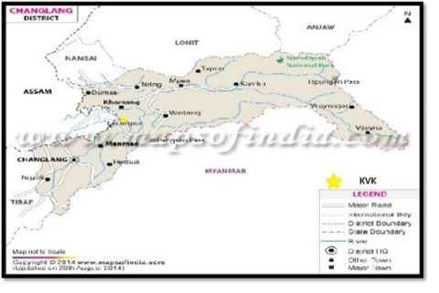
District map showing the location of KVK

DISTRICT PROFILE:

Demographic detail in the district (consider the total population of the district):

Sl. No. Particulars Value
1 Male population in the district 76948
2 Female population in the district 71278
3 Total population in the district 148226
4 Sex ratio 926:1000
5 Rural population 128998
6 Urban population 19228
7 Population under BPL -
8 Population density per sq. km 32
9 Total number of household in the district 29521
10 Number of rural household  
11 Number of urban household  
12 Average number of persons per family 5.02
13 Literacy rate of male (%) 68.93
14 Literacy rate of female (%) 49.84
15 Average literacy rate (%) 59.80
16 Languages spoken in the district Assamese, Tangsa, Singpho, Tutsa, Lisu, Nocte, Hindi

Details on ST population (consider only the ST population)

S.no. Particulars Value
1 Male ST population ---
2 Female ST population ---
3 Total ST population 53878
4 ST Population under BPL ---
5 Literacy rate of ST male (%) ---
6 Literacy rate of ST female (%) ---
7 Literacy rate of ST population (%) ---

*kindly fill population as per 2011 census

Details on SC population (consider only the SC population):

S.no. Particulars Value
1 Male SC population ---
2 Female SC population ---
3 Total SC population ---
4 SC Population under BPL ---
5 Literacy rate of SC male (%) ---
6 Literacy rate of SC female (%) ---
7 Literacy rate of SC population (%) ---

RELIGION IN THE DISTRICT

S.no. Religion % of population in the district
1 Hindu 30.1
2 Muslim 1.44
3 Christian 23.1
4 Buddhist 36.3
5 Indigenous ( Rangfrah) 8.5

*add extra row if required

DETAILS OF SCHEDULE TRIBE IN THE DISTRICT

S.no. Name of tribe Language spoken
1 Tangsa Tangsa
2 Singpho Singpho
3 Tutsa Tutsa
4 Lisu Lisu
5 Nocte Nocte

LAND UTILIZATION PATTERN IN THE DISTRICT (mention the unit)

Sl. No. Particulars Value (mention the unit while filling the data)
1 Total geographical area 4662 Sq. K.M.
2 Cultivable area 32.09 ha.
3 Forest land ---
4 Area not available for cultivation or land under non agricultural use 3.85 ha.
5 Permanent pasture and grazing land 1.48
6 Net sown area 16.82 ha.
7 Area sown more than once 8.58 ha.
8 Total or gross cropped area (sum of net sown area and area sown more than once) 25.8 ha
9 Cropping intensity 151.01%
10 Net irrigated area 7.965 ha.
11 Gross irrigated area 7.965 ha.
12 Rainfed area 10.401 ha
13 Source of water for irrigation Rain

TYPE OF SOIL IN THE DISTRICT

S.no. Soil type Characteristics
1 Acidic soil 1. High in organic matter content and moderate to poor base saturation in upland and gently sloping plains.
2. Mildly alkaline in nature with high base saturation in flood plains.
2 Sandy soil Excessively drained soil in moderately shallow channel bars

CLIMATIC PARAMETERS IN THE DISTRICT

Sl. No. Parameter Value (mention the unit while filling the value)
1 Average annual rainfall 3800 – 4866 mm
2 Maximum average temperature 26.96°C
3 Minimum average temperature 18.6°C
4 Maximum average relative humidity 91%
5 Minimum average relative humidity 54.5%

CATEGORY OF FARMERS

Sl. No. Category of farmer % of total farmer
1 Large (more than 10 ha) 4
2 Medium (4 to 10 ha) 8
3 Semi medium (2 to 4 ha) 12
4 Small (1 to 2 ha) 19
5 Marginal (less than 1 ha) 49
6 Agricultural labour 8

AREA, PRODUCTION AND PRODUCTIVITY OF DIFFERENT CROPS

Name of major cereal crops
Sl. No. Name of the crop Growing season Area (ha) Production (q) Productivity (q/ha)
1 Paddy April-November 15260 490300 32.13
2 Maize February- May 1240 13700 11.0
Name of major pulse crops
Sl. No. Name of the crop Growing season Area (ha) Production (q) Productivity (q/ha)
1 Black gram and green gram August- November 932 9240 9.91
Name of major oilseed crops
Sl. No. Name of the crop Growing season Area (ha) Production (q) Productivity (q/ha)
1 Mustard, Seasmum November-February 4918 46600 9.47
Name of major vegetable crops
Sl. No. Name of the crop Growing season Area (ha) Production (q) Productivity (q/ha)
1 Potato October-December 172 37840 220
2 Chilli Throughout the year 49 3952 80.6
3 Beans October-May 30 8521 284
4 Brinjal October-May 27 9400 348
5 Pumpkin February-May 25 6080 243.2
6 Tomato October-May 13 4581 352.3
7 Cucumber February-May 18 4620 256.6
Name of major fruit crops
Sl. No. Name of the crop Area (ha) Production (q) Productivity (q/ha)
1 Orange 301 192600 639.86
2 Pineapple 97 255202 2630.94
3 Banana 128 41710 325.86
4 Litchi 28 1911 68.25
5 Lemon 40 202 5.05
6 Guava 15 4651 310.06
Name of major plantation crops
Sl. No. Name of the crop Area (ha) Production (q) Productivity (q/ha)
1 Tea 361 - -
2 Arecanut 356 449700 1263.2
Name of major spice crops
Sl. No. Name of the crop Growing season Area (ha) Production (q) Productivity (q/ha)
1 Ginger March-September 254 178820 704
2 Large Cardamom April-December 966 29870 30.92
3 Black Pepper March-September 85 25 0.29
Name of major fodder crops
Sl. No. Name of the crop Growing season Area (ha) Production (q) Productivity (q/ha)
1 Sugarcane October-March 4340 2674500 616.24
MAJOR CROPPING SYSTEMS (eg. Rice-pea-greengram; rice –fallow etc.)
Sl. No. Name of major cropping system
1 Shifting cultivation
2 Agri-Horti farming system
3 Agri-Horti-Silvi-farming system
4 Backyard rearing of animals and birds
DETAILS OF LIVESTOCK, POULTRY, etc. IN THE DISTRICT
Sl. No. Category Name of breed Population
1 Cattle Desi 3738
    Jersey cross 770
2 Buffalo Desi (Swamp buffalo) NA
3 Goat Assam hill goat 19040
4 Pig Cross breed 16530
5 Sheep NA NA
6 Rabbit NA NA
7 Poultry    
  a. Hens Desi 178540
  b. Duck    
  c. Turkey    
  d.    
DETAILS OF FISHERY IN THE DISTRICT
Sl. No. Category Common name/species of fish Total fish production in the district
1 Fishery Catla, Rohu, Mrigal, Silver carp, Grass carp, Common carp 205.2 tons
NAME OF INTEGRATED FARMING SYSTEMS PREVALENT IN THE DISTRICT
Sl. No. Name of integrated farming systems Components
1 Integrated Farming System Pig cum fish farming system
1 Integrated Farming System Duck cum fish farming system

Major identified problems in the district in relation to agriculture and allied activities:

Lack of irrigation facility during off season.

Non-availability of good quality seeds.

Lack of modern agricultural tools.

Non-availability of medicines and vaccines for livestock.

Non-availability of quality fish seeds at the right time of stocking.

Transportation

Marketing.

Cold storage facilities.

AGRO TOURISM (IF ANY): NA

SIGNIFICANT ACHIEVEMENTS IN THE LAST FIVE YEARS

1. Best KVK award for executing the project of Cluster Front Line Demonstration (CFLD) on pulses for the year 2020-21.

2. Best KVK award among the KVKs of Arunachal Pradesh for implementing the NEH (North-Eastern Hill) component for the year 2020-21.

3. Best KVK award among the KVKs of Arunachal Pradesh for popularization of integrated farming system in the district for the year 2021-22.

4. Best exhibition stall at state hood day by the district administration, Changlang for the year 2021-22.